|
|
Click
here to see whats new in version 5.0
Available for Mac and Windows.
Fast, realistic
ray tracing and intuitive controls
It's
easy to adjust the lighting, shadows, reflection, and many other
settings. You can learn the program and get great results right
away!
Natural
object creation tools
Create rocks,
clouds, bushes, oak, redwood, palm and sweetgum trees with the built-in
object generators.
Visual terrain
loading screen
Just
click on the state map to quickly locate and load the area you want.
Easily loads and combines multiple areas.
100%
coverage of USA
Fourteen 3D terrain
CD-ROMs (available separately) contain over 54,000 high resolution
terrain models. The program CD-ROM includes 960 models.
Imports
USGS terrain models
You can load
and combine USGS DEMs (7.5 minute and 1 degree), SDTS DEMs, and
GTOPO 30 files. See what Natural Scene Designer
can do with USGS terrain models and map overlays.
Imports
and renders 3D objects
Objects
can scaled, rotated, and moved.
360
degree panoramas
Natural Scene
Designer can create 360 degree panoramas from any location. Then
you can interactively view the scene in all directions. See
an example.
Exports
terrain models
You
can export a terrain as a DEM, DXF, 3DS, grayscale, PGM, or 3DMF
file along with a matching color map.
|
|
|
|
|
|
Rendering
Ray
tracing, optimized for natural landscapes, provides the greatest
level of realism. A Quick Test renderer allows you to check scene
composition instantly. The ray tracing renderer features anti-aliasing,
shadows, reflections, and transparency.
Mac OS X
Support
Includes a native Mac OS X version, which
runs on MacOS 10.0 through 10.3. Also includes a MacOS 9 version.
Dual Processor
Support
Utilizes dual processors simultaneously
during ray tracing resulting in nearly a 2X speed improvement!
Animation
The
built-in animation system lets you draw a camera flight path on
the map and create an animation. The camera can be set to automatically
bank (like an airplane) around curves. 3D objects and clouds can
be set in motion during an animation. They are saved as QuickTime
movies. Animations can be rendered in multiple sessions.
Terrain Editor
Includes
a built in terrain editor. You can easily change the elevation in
areas of the terrain, or use tools to raise or lower it, while blending
it into the surroundings. The previous terrain edit can be undone
if desired.
QuickTime
VR
Natural
Scene Designer can create 360 degree panoramas from any location.
Then interactively view the scene in all directions using a movie
player program. See an example.
Terrain Models
The
CD-ROM included with this program contains nearly one thousand 30
meter terrain models of California and Nevada. A Mars terrain with
a matching photograph overlay is included also. Natural Scene Designer
can automatically combine multiple adjacent terrain models, so you
are not limited to working with only one at a time.
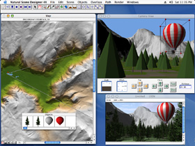
Map Window
The
Map window shows a shaded relief view of the terrain. It also shows
the current camera location, field of view, flight path, and 3D
objects placed in the scene. The program can zoom in on an area
of interest up to a magnification factor of 512X. A profile mode
is available to show the altitude changes of the camera flight path.
Camera Window
The
Camera window always shows the current view. Push buttons let you
easily pan or move the camera viewpoint.
|
|
Input File
Formats
Natural
Scene Designer imports Digital Elevation Models (DEMs), SDTS files,
NED files (BIL, GridFloat, TIFF DEM), SRTM (Space Shuttle) and GTOPO
30 files from the U.S. Geological Survey. 3D Studio (3DS) and QuickDraw
3D (3DMF) objects may be imported and placed in scenes. Textures
(if present) are mapped to the object and rendered.
Output File
Formats
Natural
Scene Designer exports grayscale DEMs, grayscale PGM, USGS DEMs,
3DS, 3DMF and DXF files for use in other 3D programs. Rendered images
can be saved as TIFF, JPEG or PICT. Animations are saved as QuickTime
files. 360 degree panoramas may be saved as QuickTime VR movie files.
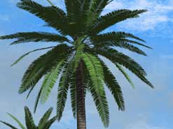
Trees and
Bushes
Add
realistic bushes. redwood, oak, palm, and sweet gum trees to your
landscape scenes. The size, leaf and bark colors, leaf percent,
elevation range and density of coverage can be changed.
Rocks
The
size and shape of each rock, its color, texture, and other parameters
are adjustable. A wide variety of rocks can be created.
Sky and Clouds
To
add realism and depth, Natural Scene Designer lets you choose sky
colors or a blend to create a gradual transition from the sky zenith
to the horizon. The amount of haze is adjustable. Natural Scene
Designer uses fractal methods to create realistic cirrus and cumulus
clouds. You can set the cloud altitude, density of coverage, speed
and their direction of movement during animations.
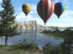
Water
Natural
Scene Designer can ray trace water realistically using it's natural
properties of transparency, reflection, and refraction. Add lakes
to a landscape by clicking over the desired lake location in the
Map window. Specify an ocean level to fill the terrain below the
chosen level.
System
Requirements
A PC with a 200
MHz or faster processor, Windows 98, NT, 2000, or XP, 64MB of RAM,
and a CD-ROM drive. Also requires QuickTime, which is included on
the CD-ROM.
|
|